
Hydrological Cycle Processes
- Drainage basins are subsystems of the global hydrological cycle, they drain all the water which lands on the Earth's surface
- Drainage basins can cover many square miles/km over a number of countries e.g. the Nile River basin drainage area is more than 3 million km2 over 12 countries with 73 % of the drainage basin in Sudan and Egypt
- An individual drainage basin is the area drained by a river and its tributaries, this is also known as the catchment area
- The boundary of the drainage basin is the watershed
- As a subsystem of the hydrological cycle, drainage basins are open systems this means that they have inputs and outputs

Drainage basin features
- All drainage basins have some features in common:
- Watershed
- Source
- Confluence
- Tributary
- Mouth

- The drainage basin as an open system: note that the atmosphere can be both a store and a transfer – clouds store but also move water around the planet
- As an open system, drainage basins have inputs, outputs, stores and flows
- Inputs are the addition of water to a drainage basin through precipitation
- Inputs vary throughout the year (rain, sleet, snow, location etc) and intensities (flood, drought, temperature etc) and frequency (seasonal, monsoon etc)
- The three main types of rainfall in the UK are:
- Orographic (relief) rainfall where warm, moist air is forced to rise over high ground

Orographic (relief) rainfall
-
- Frontal rainfall occurs when warm and cold air masses meet and the warm air rises over the cold air
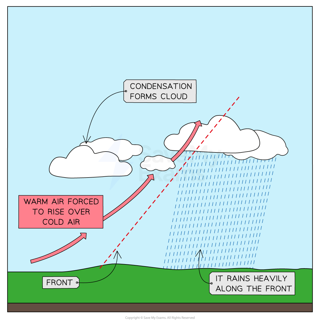
Frontal rainfall
- Convectional rainfall occurs when the ground heats the air above it
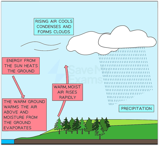
Convectional rainfall
- Flows in a drainage basin can be either above or below ground
- Above:
- Throughfall is precipitation that makes it to the ground without interception by the plant canopy
- Drip flow is water that flows off leaves and drips to the ground. Some leaves have developed drip tips and waxy surfaces
- Trunk and stem is the flow of water down the stems of plants or trunks of trees
- Overland surface flow is when water flows over the land surface. Two types, channel and sheet flow
- Channel flow is where water flows in small channels or rills (<30cm width/depth) in a defined stream pattern
- Sheet flow is a layer of water on the surface, either due to excess surface flow from increased precipitation or water cannot infiltrate quickly enough
- Interception by vegetation can prevent as much as 40% of precipitation from reaching the ground
- It slows the passage of water to the surface and reduces the amount that reaches the ground – some or all will evaporate and the rest will take a longer route over leaves, trees etc.
- This is important, as it reduces the amount available for overland/surface flow and therefore, there is a reduction in soil erosion and flooding
- Buildings also prevent water from reaching the ground
- The water is instead diverted into gutters and drains or evaporates
- Below:
- Infiltration is where water enters small openings and pores in the ground from the surface.
- Throughflow is the lateral (sideways) movement of water through the upper soil, along lines of seepage called percaline
- Percolation is where water flows down through the soil layers and underlying rock is pulled down through gravity. The rate of travel is determined through porosity (soil) and permeability (rock)
- Baseflow / Groundwater flow water that has infiltrated and percolated into the bedrock and below the water, table to feed springs, river channels and recharge aquifers (recharge will only occur when there is an excess of water)
- Above:
- Outputs are the losses of water from a drainage basin in various forms
- River discharge is the volume of water passing a point in the river channel at a given unit of time and expressed as cubic metres per second or ‘cumecs’ (m3/sec)
Exam Tip
Do not get confused between throughfall and throughflow.
Throughfall is above ground and is where water transfers through the canopy of trees etc. to the ground without any interception.
Throughflow occurs below ground and is the transfer of water laterally below the surface after infiltration.
