Past & Present Ice Cover (Edexcel A Level Geography)

Revision Note

Jacque Cartwright

Expertise

Geography Content Creator

The Cryosphere

  • The cryosphere is all the frozen regions on Earth and covers 13% of the planet's surface
  • The term comes from the Greek word 'kryo', meaning cold
  • Ice can be found in
    • High latitudes - Arctic and Antarctic Circles of more than 65° north and south of the equator
    • High altitudes - found in mountain ranges, which can be at any latitude (Drakensberg Mountains, SA is over 3000m high at a latitude of 29° south of the equator)
  • Features of the cryosphere include: 
    • Snow
    • Ice (69% of the world's freshwater is stored as ice)
    • Permafrost and frozen ground - not all frozen ground is permafrost
    • Glaciers
    • Ice caps, sheets and shelves
    • Icebergs
    • Sea, river and lake ice

cryosphere

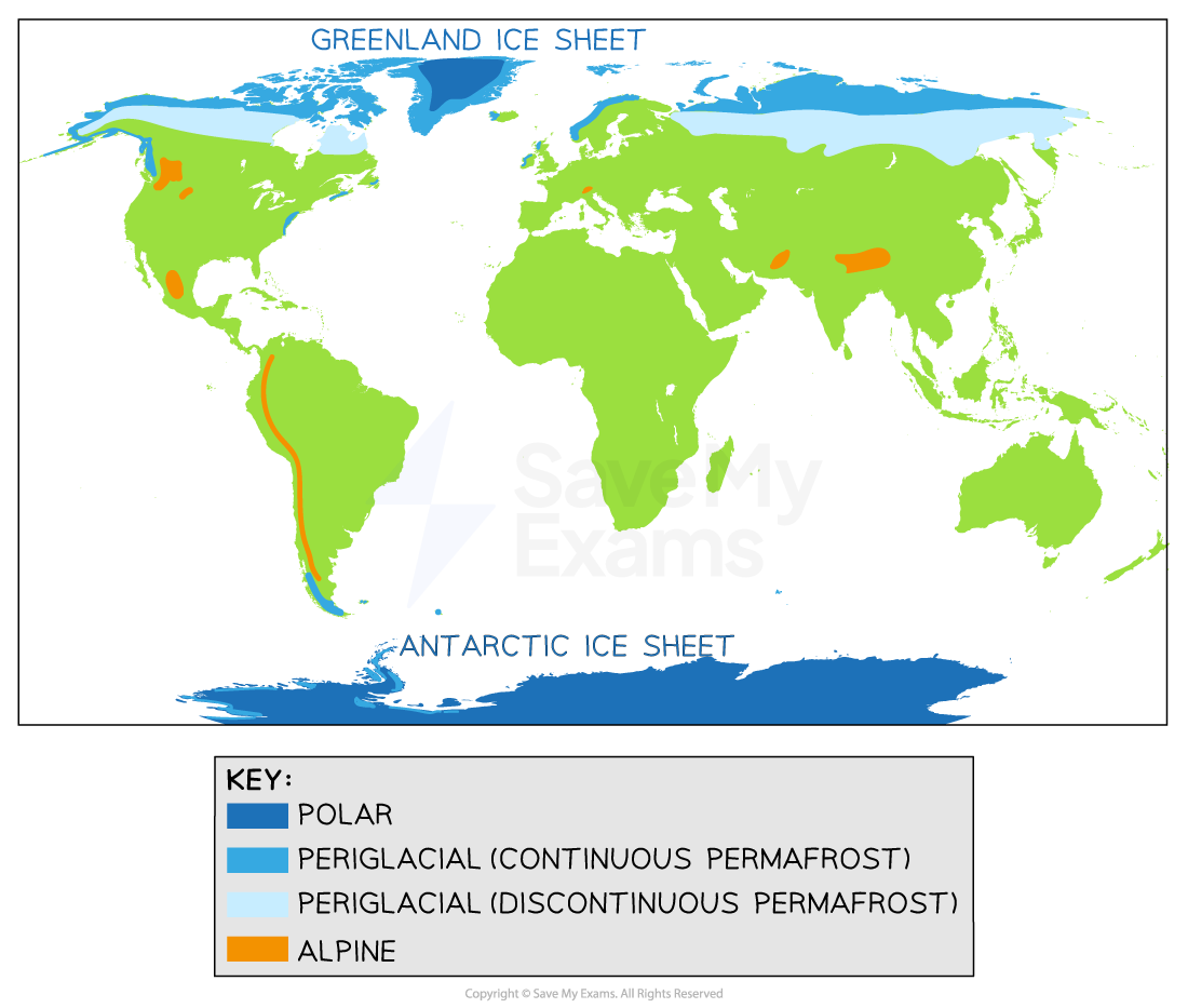
Parts of the cryosphere

  • Most of the cryosphere is found in Antarctica (85%) and the Arctic polar region (12%), as ice sheets, shelf ice, and permafrost
    • The largest, single ice mass on Earth is the Antarctic ice sheet, covering 8.3% of the global land surface 
    •  It took millions of years to form; is up to 4.8 km (3 mi) deep in parts; and covers approx. 14 million km² (5.4 million mi²) and contains 30 million km³ of ice
    • If it melted, it could raise sea levels by 58 meters (190 feet) 
  • Permafrost areas are significant global carbon stores and help regulate levels of carbon in the atmosphere
  • The cryosphere helps regulate Earth’s climate through its high surface albedo effect
  • As the climate warms, the cryosphere also changes through feedback mechanisms, which further influences the climate:
    • Increased snow and ice melt, exposes more dark surfaces to insolation
    • Which increases surface absorption of solar radiation, causing further melting and release of stored carbon and methane into the atmosphere, which leads to further atmospheric warming
    • This is a positive feedback loop, which exacerbates the impacts of climate change

Classification of Ice Masses

  • There are two groups of ice masses:
    • Constrained - these do not have a dome-like structure, so the flow and shape of the ice is influenced by its surroundings - valley, piedmont and cirque glaciers
    • Unconstrained - the flow and shape of this ice is not influenced by its surroundings - ice sheets, shelves and caps
      • These have the basic shape of a broad, slowly moving, central dome, with channels of faster-moving ice that flows to, and at, its margins

Unconstrained 

  • Ice sheets
    • Continuous masses of ice, that cover areas greater than 50,000 km³ 
    • With no surrounding mountains or features to contain them, continental glaciers spread out and cover the surface
    • They spread out from the centre and can cover whole valleys, plains and mountain ranges with ice
    • Sometimes only the tips of mountain peaks show above the ice, called nunataks
    • In 2009, Antarctic scientists found a mountain range, as large as the European Alps, hidden under 2.5 miles (4km) of ice 
  • Ice caps
    • Cover areas of less than 50,000km³
    • Usually centred on a mountain's high point (called a massif), the ice flows flow in multiple directions to form a cap
    • This flow of ice feeds into a series of glaciers at its edges
    • Polar ice caps are not strictly 'caps' as they are greater than 50,000km³
  • Ice shelves
    • These are thick, floating slabs of ice, permanently attached to a landmass
    • Found where ice flows down to the coast and out onto the ocean's surface
    • Only found in Greenland, Northern Canada, Antarctica and the Russian Arctic

Constrained 

  • Ice fields
    • Ice that covers a mountain plateau, but does not extend the high-altitude area
    • Not thick enough to bury the topography and covers 5 -1500km³ 
    • Examples include the Himalayas, Rockies, Andes, and the Southern Alps of New Zealand 
  • Piedmont glaciers
    • Found at the foot of mountains, where a mass of ice has flowed downslope and fans out, forming lobes of continuous ice
  • Valley glacier
    • Ice is surrounded by high mountains and fills the valley
    • They are usually ribbon-shaped and vary in length from a few kilometres to over 100km 
    • They can be a single feature or made up of multiple glacial tributaries from surrounding valleys
    • Most begin as mountain glaciers and spread/flow to gorges, basins and across the valley floor
    • Examples include the Andes, Himalayas and European Alps
  • Cirque glaciers
    • Most common type of glacier and found in nearly all areas where snow and ice accumulate - e.g. alpine regions
    • Confined to either the upper parts of a glacial trough or within the hollowed, cirque basin itself
    • It is the basin that dictates the size, shape and flow of the glacier
    • Niche glaciers are smaller versions of cirque glaciers

Thermal regime of ice masses

  • This refers to an ice mass's basal temperature and indicates whether water or ice will be present

Pressure melting point (pmp)

  • The temperature at which ice melts at a given pressure is the pressure melting point (pmp)
  • The melting point of water depends on air pressure above the ice
  • As air pressure increases, the temperature at which ice melts lowers
  • At 1 atmosphere pressure, the melting point of ice is 0°C
  • At 200 atmospheres, the melting point decreases to -1.85°C

Warm-based glaciers

  • Occur in temperate regions such as southern Iceland and western Norway
  • They are relatively small and range in width from hundreds of meters to a few kilometres
  • Melting occurs during the summer months
  • It is this meltwater that 'lubricates' the base and sides of the glacier, which assists movement (called basal sliding) and increases rates of erosion, transportation and deposition
  • As such, all ice in these glaciers is at, or close to, the melting point of ice
  • Temperatures at the base are, therefore, at or just above the pressure melting point

Cold-based glaciers

  • Occur in polar regions such as central Greenland and Antarctica
  • They are large, vast sheets and caps of ice covering hundreds of km²
  • Temperatures remain below melting point, with low rates of precipitation, resulting in low levels of accumulation 
  • Basal temperatures remain below the pmp, therefore, basal sliding does not happen
  • This results in little erosion, transportation and deposition
  • Any movement is by internal deformation
    • The ice stays frozen to the bedrock and moves slowly at 1-2cm a day
    • Orientation of the ice crystals in the glacier, to the direction of movement, allows the crystals to slide over each other

Polythermal glaciers

  • These are glaciers with both warm and cold bases but at different altitudes
  • They usually show a cold base in their upper reaches (high altitudes)
  • At the lower altitudes, their bases are warm with meltwater

Present Day Distribution of Ice Sheets

Past glaciation

  • The last glacial maximum was 21,000 years BP, where over 30% of the Earth's surface was glaciated
  • The polar ice sheets covered much of the UK and major parts of southern Europe were periglacial
  • Sea levels dropped, and shorelines extended farther out, creating more land (water was trapped in ice sheets)
  • The climate was drier, because most of the water on Earth's surface was ice, resulting in less precipitation
  • Earth's average temperature was 6°C (average now is 14-15°C)

extent-of-global-ice-during-pleistocene-epoch

Extent of global ice during the Pleistocene epoch

  • The present-day distribution of cold environments can be divided into polar, glacial, alpine and periglacial areas
  • Polar - considered areas of permanent ice within the northern and southern extremes of the Antarctic and Arctic regions
  • They are found in areas of high latitude, with long winters and short summers, with high levels of storms and cold winds
    • The Arctic polar environment can be defined either by the Arctic circle at 66° N or by the July isotherm of 10° C
      • Isotherms are areas of the same temperature
      • July is the hottest month and areas north of this line have an average of 10°C or below
      • Winter sea ice is shrinking
    • The Antarctic is much colder than the Arctic, with strong westerly winds, cold oceans and a large landmass
    • Winter sea ice is increasing 
    • Defined by the 10°C January isotherm (January is the hottest month in the southern hemisphere)
  • Other examples include Greenland and northern Canada

distribution-of-present-day-cold-environments

Distribution of present day cold environments

Upland Glaciated Landscapes Today

  • Glaciated landscapes vary, dependent on location - polar, glacial, periglacial and alpine
  • Glaciated landscapes can be divided into active (current) or relict (past) landscapes
  • Geology influences the nature of a glaciated landscape
    • Igneous rock is harder to erode and often makes up high mountains with steep sides and hollows
      • Large amounts of poorly sorted sand, gravel, and boulders are plucked and pried from the surface and mountains
      • As the glacier flows over bedrock, the sediments trapped in the ice, are ground into a fine powder called rock flour
      • Rock flour acts as sandpaper, that polishes the surface of exposed rock to a smooth finish called glacial polish
      • Larger rock pieces scrape over the surface creating grooves called glacial striations
      • The Highlands of Scotland, the Lake District and Snowdonia (Eryri), North Wales show many relict landscapes from the Pleistocene epoch, including arêtes, erratics, cirques/corries, and corrie lakes
    • Sedimentary and metamorphic rocks are found mainly in low-lying areas (already eroded from the uplands) and are easier to erode
      • During the last Ice Age, the advancing ice sheet moved chalk, boulder clay etc. into the south and east of England 

uk-glaciated-landscape

The extent of the UK's glaciation during the last Ice Age

Exam Tip

If asked to discuss evidence of past glaciated landscapes, remember to include how relict landscapes are a partly preserved snapshot of very different conditions (climate and processes) in the past and that landforms could not have arisen without extensive glaciation in those areas. 

You've read 0 of your 0 free revision notes

Get unlimited access

to absolutely everything:

  • Downloadable PDFs
  • Unlimited Revision Notes
  • Topic Questions
  • Past Papers
  • Model Answers
  • Videos (Maths and Science)

Join the 100,000+ Students that ❤️ Save My Exams

the (exam) results speak for themselves:

Did this page help you?

Jacque Cartwright

Author: Jacque Cartwright

Jacque graduated from the Open University with a BSc in Environmental Science and Geography before doing her PGCE with the University of St David’s, Swansea. Teaching is her passion and has taught across a wide range of specifications – GCSE/IGCSE and IB but particularly loves teaching the A-level Geography. For the last 5 years Jacque has been teaching online for international schools, and she knows what is needed to pass those pesky geography exams.