Sediment Transport & Deposition (Edexcel A Level Geography)

Revision Note

Test Yourself
Bridgette

Author

Bridgette

Expertise

Geography Lead

Influences on Sediment Transport

  • Material in the sea arrives from many sources:
    • Eroded from cliffs
    • Transported by longshore drift along the coastline
    • Brought inland from offshore by constructive waves
    • Carried to the coastline by a river

Once in the water, the material is moved in different ways:

    • Traction
    • Saltation
    • Suspension
    • Solution

Direction of wave attack

  • The direction that the waves are coming from is the main factor affecting the direction of sediment transport

Longshore (littoral) drift

  • Longshore (littoral) drift is the main process of deposition and transportation along the coast 
  • Influenced by the prevailing wind, waves approach the beach at an angle
  • As the waves break, the swash carries material up the beach at the same angle
  • As the swash dies away, the backwash carries the material down the beach at right angles (90°) 
  • The process repeats, transporting material along the beach in a zig-zag movement
  • Offshore currents can contribute to the movement of sediment along or up the beach


longshore-drift

The process of longshore (littoral) drift

Current

  • Current is the flow of water in a specific direction which transports sediment
    • Surface currents are formed mainly by wind
    • Deepwater currents are also called thermohaline circulation and are caused by density differences 

thermohaline-circulation

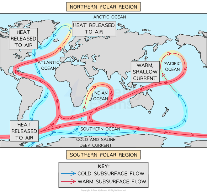
Thermohaline circulation

  • Tidal currents are associated with rising and falling tides, the greater the tidal range the greater the strength of the currents
  • Rip currents are underwater currents that occur near the coastline and transport sediment a few metres out to sea

Tides

  • The gravitational pull of the sun or moon causes tides 
  • The difference between high and low tide is known as the tidal range
  • Larger tidal ranges produce stronger tidal currents and this can transport more sediment, particularly in the areas around estuaries
  • Deposition occurs when waves lose energy 
  • Waves lose energy when: 
    • The wind slows or changes direction 
    • The wave experiences friction, usually with the sea floor as the depth decreases 
    • When the coastline changes direction such as at an estuary or headland
  • It is a gradual rather than immediate process 
  • High energy coastlines deposit large rocks and shingle but generally maintain enough energy to carry smaller sediment particles 
    • This is why these types of coastlines tend to have rocky beaches, such as Brighton on the south coast of England
  • Low energy coastlines deposit smaller sediment due to low wave velocity, creating sandy beaches

Transportation & Deposition Landforms

  • Depositional landforms occur at low energy coastlines when the waves do not have enough energy to carry a large sediment load
  • The most common depositional landform is a beach
    • Beaches build up due to constructive waves
    • They form in sheltered areas such as bays
    • Beach formation is more common in summer when there are fewer destructive waves
  • Beaches can be drift-aligned or swash-aligned 
    • Drift-aligned beaches form where longshore drift moves the sediment along the beach as waves approach at an oblique angle 
    • This will often culminate in a spit where the coastline changes direction 
    • Swash-aligned beaches form where the energy is low 
    • The waves are more parallel to the shore in swash aligned environments so there is little horizontal or lateral movement of sediment 
  • Spits are created due to longshore drift
    • A spit is an extended stretch of sand or shingle that extends out to sea from the shore 
    • Sediment is transported by waves along a coastline
    • When the coastline changes direction the waves no longer have the energy to carry the sediment and it is deposited 
    • The build-up of deposited sediment out to sea, often into an estuary, is called a spit 
    • The spit often has a curved end or hooks due to a secondary prevailing wind

spit-formation_1

Formation of spit

  • As spits form across an estuary or around a headland there can also be the formation of tombolos and bars where the sediment meets either an island or the opposite side of a headland respectively 
    • These are formed in the same way, through longshore drift and deposition
    • Bars can also form offshore
    • These are raised ridges of sediment away from the shore 
    • They form where sediment level is high, and the sea is shallow 
  • Bars that form as spits extend to join two headlands are also known as barrier beaches
    • Water trapped behind the barrier beach is called a lagoon
  • Sandbars can also form offshore due to the action of breaking waves

Bar formation

Depositional landforms

Lagoon

  • A lagoon is where a small body of water is cut off from the sea 
  • A lagoon may form behind a bar or tombolo
  • Lagoons do not last forever and may fill with sediment and form new land

Tombolo  

  • A tombolo is formed when a spit joins the mainland to an island
  • Chesil Beach in Dorset is a tombolo, as the mainland is joined to the Isle of Portland 

Barrier island

  • Barrier islands form parallel to the coast 
  • The main difference between a bar and a barrier island is that a bar joins two headlands, whereas a barrier island is open at one or both ends

tombolo-barrier-island

Salt marshes and sand dunes

  • Behind spits and barrier beaches the area is very sheltered, tidal currents and river currents meet leading to lots of deposition 
    • This can lead to the formation of salt marshes 
    • Salt-tolerant species colonise these sheltered, flat muddy areas 
    • They are covered at high tide and exposed at low tide 
  • Deposition can also lead to the formation of sand dunes 
    • Sand dunes are formed in areas where there is a large quantity of sand, a large tidal range, and onshore prevailing winds 
    • When sand is trapped towards the back of the beach due to an obstacle then dunes will develop forming rows at right angles to the prevailing wind
    • Pioneer plant species hold the sand together and stabilise the dune 
    • Other plants are then able to thrive in the environment which leads to the development of the dune ecosystem, this is called plant succession

Exam Tip

The development of sand dunes and salt marshes is covered in detail earlier in the revision notes during the section on the role of vegetation.

Sediment Cell Concept

  • There are a range of sources of sediments in the coastal zone 
  • Most coastal sediment is brought to the shore by rivers
  • Cliff erosion is also an important source of sediment at most coastlines
    • Where coastlines are retreating by a few metres a year there is a large input of sediment to the coastal zone 
  • Wind can also transport sediment to the shore and this can lead to the build-up of sand dunes 
  • In high latitude coastal areas glaciers break off into the sea and sediment that was trapped within the ice is deposited at the coastal zone 
  • Sediment Cells are an important way of understanding the coastal system
    • They can be considered a closed system as most sediment movement is contained within the cell 
    • There are 11 sediment cells around the UK coastline 
    • Sediment cells can be divided into sub-cells where the inputs (sources), stores (sinks), transfers, and outputs within the system can all be identified 

UK sediment-cells

The sediment cells of England and Wales

a-sediment-cell

  • The sediment budget is the balance between the inputs and outputs of sediment in the system 
  • Coastal systems should be in a state where the sediment budget is in a state of dynamic equilibrium 
  • However, human activity and natural changes like climate change can disturb the state of dynamic equilibrium.

Exam Tip

In the exam you may be asked about the role of sediment transport in a coastal landscape. To achieve full marks you need to ensure that you explain the formation of more than one landform because the question is asking about the entire landscape rather than a specific landform.

You've read 0 of your 0 free revision notes

Get unlimited access

to absolutely everything:

  • Downloadable PDFs
  • Unlimited Revision Notes
  • Topic Questions
  • Past Papers
  • Model Answers
  • Videos (Maths and Science)

Join the 100,000+ Students that ❤️ Save My Exams

the (exam) results speak for themselves:

Did this page help you?

Bridgette

Author: Bridgette

After graduating with a degree in Geography, Bridgette completed a PGCE over 25 years ago. She later gained an MA Learning, Technology and Education from the University of Nottingham focussing on online learning. At a time when the study of geography has never been more important, Bridgette is passionate about creating content which supports students in achieving their potential in geography and builds their confidence.