
Managing the Impacts of River Flooding
Flood prediction
- Prediction of flooding means that steps can be taken to manage flooding
- Flood hydrographs are used to predict the reaction of a river discharge to a rainfall event
- A flood hydrograph shows the changes in river discharge after a storm event
- The graph shows a short period of time, usually 24 hours
- The flood hydrograph has a number of features:
- Base flow
- Peak rainfall
- Rising limb
- Peak discharge
- Lag time
- Recessional limb

Flood Hydrograph in an Urban Area
- The key factor in assessing the flood risk is time taken for the precipitation to reach the river from where it falls - the lag time
- Rivers with a short lag time and steep rising limb have a much greater risk of flooding
- The water reaches the river rapidly and the river may not have the capacity to cope with the influx of water
- Rivers with a long lag time and gentle rising limb have a lower flood risk
- The water reaches the river more slowly causing a gradual increase in discharge
- The lag time depends on some human and physical factors
- These lead to increased overland flow which shortens the lag time
Human and Physical Factors which Increase the Risk of Flooding
| Human Factors | Impact |
| Deforestation |
Lack of trees reduces interception and infiltration, increasing overland flow |
| Urbanisation |
Impermeable concrete and tarmac increase overland flow Water flows into the drains reaching the river rapidly |
| Agriculture |
Bare soil and ploughing increase overland flow |
| Climate Change |
Rising global temperatures may increase storm frequency and intensity |
| Physical Factors | Impact |
| Relief |
Steep slopes reduce infiltration and increase overland flow |
| Rock Type |
Impermeable rocks reduce percolation and increase overland flow |
| Soil |
Frozen, saturated or compacted soil reduces infiltration and increases overland flow Some soil types such as clay reduce infiltration and increase overland flow |
| Weather |
Heavy or prolonged rainfall means that the rate at which water reaches the surface exceeds the infiltration rate leading to increased overland flow After a period of snow rising temperatures can cause rapid melting which increases overland flow |
| Seasonal Variations |
Flooding in Northern Europe tend to occur in the autumn and winter when rainfall is more frequent In areas affected by monsoon much of the annual rainfall occurs in a few weeks saturating the ground and increasing overland flow Higher temperatures in spring leads to snow melt in mountainous areas increasing overland flow |
| Drainage Density |
Where drainage density is high there are many tributaries taking water to the main channel causing a rapid increase in discharge |
| Vegetation |
Where there is little natural vegetation there is reduced interception leading to increased overland flow |
Worked example
Study Fig 1, which is a hydrograph of a river after a storm.
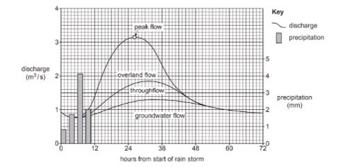
How long after the start of the rain storm is the peak flow?
..................................................... hours
[1]
-
Answer:
- Between 26-28 hours
Exam Tip
In the exam, you may be asked to explain the causes of flooding. Remember this means that you need to give connections between factors such as deforestation and the increased flood risk. Rather than simply stating that deforestation increases flood risk you need to explain the reasons - decreased interception and infiltration, leading to increased overland flow and shorter lag time.
Flood management
- The key cause of flooding is the amount and duration of precipitation this cannot be altered
- There are a number of methods of managing floods and reducing the severity and/or impact
- The two main categories of flood management are hard and soft engineering:
- Hard engineering involves building structures or changing the river channel
- Soft engineering works with natural processes of the river and surrounding environment
- Soft engineering is increasingly popular
- Soft engineering is an example of mitigation where schemes aim to minimise damage rather than trying to prevent the flooding
Examples of Hard and Soft Engineering
| Hard Engineering | Soft Engineering |
|
Dams and reservoirs enable the amount of discharge downstream to be controlled |
River restoration, this supports the river by restoring it back to its original regime - putting meanders back in, stabilising banks and connecting to flood plains |
|
Embankments or levées increase the capacity of the river |
Wetland conservation these areas provide somewhere for excess water to go and slow the flow of the flood water |
|
Straightened channels mean that the river flows more quickly pass vulnerable areas, reducing the risk of flooding |
Catchment management plans assess the risk of flooding in an area and outline how this will be managed |
|
Flood relief channels allow some water to flow out of the main channel reducing the discharge |
Flood plain zoning means that only certain land uses are allowed on the flood plain, reducing the risk |
|
Spillways or overflow channels these take excess water away from the main channel |
Afforestation involves the planting of vegetation and trees to increase interception and infiltration |
- Other methods that can be used to decrease the risk of flooding are:
- Leaving the stubble on the fields after the crop is harvested helps to stabilise the soil and increase infiltration
- Contour ploughing which involves ploughing fields across the slope rather than up and down. This gives the water more time to infiltrate and stops the ploughed furrows becoming channels for water
- Improved forecasting and flood warnings
- Dredging the rivers to increase capacity, however this often leads to the need for concrete reinforcement of the banks

