Syllabus Edition
First teaching 2025
First exams 2027
River Landforms (Cambridge (CIE) IGCSE Geography) : Revision Note

Landforms in the river upper course
The changes in river channel characteristics, lead to changes in the river landscape
The upland and lowland areas of rivers have distinctive landforms
Upland:
waterfalls
gorges
v-shaped valleys
interlocking spurs
Waterfalls and gorges
Waterfalls form when there is a drop in the riverbed from one level to another
This drop is often due to changes in the hardness of the rock, where hard rock overlies soft rock
Hydraulic action and abrasion are the main erosional processes
The soft rock erodes quicker, undercutting the hard rock and creating a plunge pool
This leads to the development of an overhang of hard rock, which, eventually, over time, collapses
The overhang falls into the plunge pool, increasing abrasion and making the plunge pool deeper
The process then begins again and the waterfall retreats upstream leaving a steep-sided gorge

V-shaped valleys
Vertical erosion is dominant in the upper course of the river
This cuts down into the riverbed and deepens the river channel
Weathering and mass movement lead to material from the valley sides collapsing into the river, forming a steep v-shaped valley

Interlocking spurs
In the upper course of the river, the channel starts to meander
Erosion happens on the outside of the bend
In the upland areas this forms interlocking spurs

Potholes
Potholes are round depressions in the riverbed
They are formed by abrasion
Where there are dips in the riverbed, the river flow can cause the sediment to spin
This erodes the dip, forming a circular hollow (pothole)
As the size of the hollow increases, larger material becomes trapped in the pothole
This further increases the erosion of the pothole
Landforms in the river's middle course
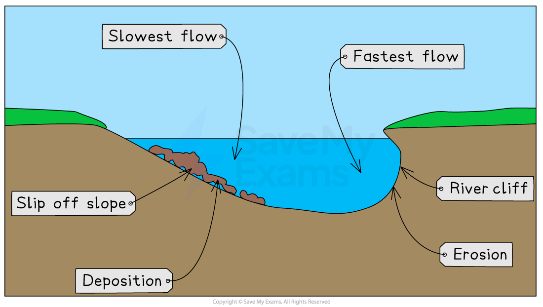
Meanders
In the middle and lower course of a river, lateral erosion is dominant
Meanders increase in size
The fastest water flow (thalweg) is on the outside of the river bends, leading to erosion
The erosion undercuts the riverbank, forming a river cliff
The riverbank collapses and the edge of the meander moves further out
The slowest flow is on the inside of the river bends, leading to deposition
The deposits form a slip-off slope
Deposition on one side and erosion on the other leads to the meander migrating across the valley
Oxbow lakes
With distance downstream, the size of the meanders increases
The erosion on outside bends can eventually lead to the formation of a meander neck
At a time of the flood, the river may cut through the neck of the meander, forming a straighter course for the water
The flow of water at entry and exit from the meander will be slower, leading to deposition
The meander becomes cut off from the main river channel, forming an oxbow lake

Examiner Tips and Tricks
Remember when describing the formation of oxbow lakes, it is important to state that the river will break through the neck of the meander during a flood. At other times, the river does not have enough power to break through.
Landforms in the river's lower course
Floodplains and levees
Floodplains are flat expanses of land on either side of the river
The migration of meanders leads to the formation of the floodplain
High discharge may cause the river to overflow the banks
More of the water is in contact with the land surface as the water spreads across the floodplain
Increased friction reduces velocity and material is deposited across the floodplain, gradually increasing the floodplain height
The heaviest material is deposited first, nearest to the river channel, forming natural embankments called levees

River mouth
A river enters a sea or lake at its mouth
This may be in different forms, including
estuaries
deltas
narrow mouth
This is dependent on:
the amount of sediment the river is carrying
the strength of the waves/tides
Estuary
An estuary is a wide, deep mouth
It forms the change between the river and the sea and is where freshwater and saltwater mix
Deltas
Rivers must carry a large amount of sediment for deltas to form
Delta formation requires a rapid drop in river velocity
This leads to the deposition of sediment
As the sediment is dropped it builds up eventually blocking water flow and forming distributaries
There are a variety of delta formations, such as arcuate and bird’s foot
Types of delta


You've read 0 of your 5 free revision notes this week
Sign up now. It’s free!
Did this page help you?
