Global Desert Systems (AQA A Level Geography): Revision Note
Exam code: 7037
Hot Deserts as a System
Deserts can be hot or cold with high levels of aridity
They are defined as:
Areas that receive less than 250mm of precipitation per annum
Deserts are described in terms of their deficiencies:
Water
Soil
Vegetation
Population
Deserts produce the smallest amounts of organic matter and have the lowest net primary production (NPP)
Desert environments are natural open systems with inputs, outputs, transfers/flows and stores of sediment, water and energy
Table of Desert System Elements
Inputs | Outputs | Stores | Flows/Transfers |
|---|---|---|---|
Sun | Landforms of erosion and deposition | Sand and sand dunes | Wind |
Wind | Loss of water through evaporation, transpiration and rivers | Rivers and lakes | Water |
Water | Loss of sand/sediments by wind | Salt pans/playas | Insolation |
Weathering sediments | A build-up of sand through time | Plants | Weathering |
Human activity | Human activity - desertification | Animals | Mass movement |
Desert systems are generally in dynamic equilibrium, where the inputs and outputs are balanced, for instance:
Seasonal winds lead to small, short-term changes in a sand dune's profile
However, overall the shape of the dune mostly remains the same
Any changes to an input or output can cause positive or negative feedback loops
Positive feedback results in the change being enhanced
Less vegetation reduces evaporation and lowers humidity which reduces precipitation rates leading to less vegetation etc.
Negative feedback restores balance - it checks any change
Temperature increase raises evaporation rates and dries the surrounding surface, making it easier to erode
Dust clouds form, which blocks some insolation, reducing temperatures and slowing evaporation
Examiner Tips and Tricks
It is important that you use the systems theory in your answers, including feedback loops and dynamic equilibrium. Open systems are self-regulating. They will adjust themselves to flows of energy and matter by changing the interrelationships of elements in the system, resulting in the inputs and outputs rebalancing to a steady state again (dynamic equilibrium).

Rain is low and irregular, interspersed with heavy downpours
Actual evapotranspiration is low, but the potential is high
Water from aquifers is capable of reaching the surface naturally or abstracted through wells
Distribution of Arid & Semi-Arid Regions
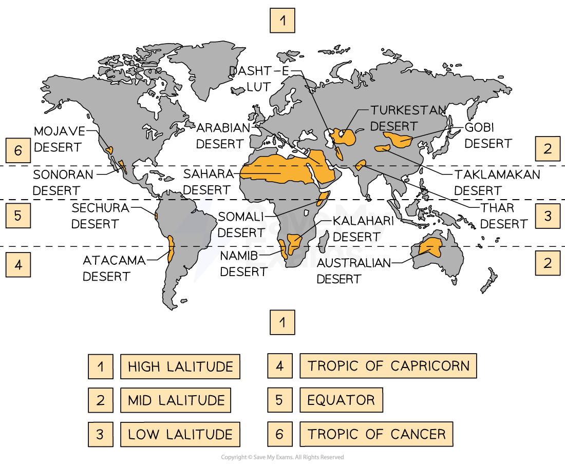
Drylands stretch across 41.3% of Earth's land surface and are present on every continent
They make up 77% of Australia’s land area, 66% of Africa, 40 % of Asia, 24% of Europe, and 15% of Latin America
They are home to approximately 20% of the world's population
Arid areas are located along the mid and low latitudes of the Tropic of Cancer and the Tropic of Capricorn
Semi-arid areas lie along the margins of these arid areas, for example, the Sahara desert is an arid area and the Sahel would be classified as a semi-arid area
Some of these areas are also located adjacent to mountain ranges, like the Atacama Desert which is alongside the Andes
Other patterns for the distribution of arid and semi-arid areas are the way they are situated on the western margins of their relative land masses where cold ocean currents run along the coast - the Namib desert, Africa is due to the Benguela Current running up the west coast of Africa
More arid areas lie in continental interiors where moisture is lost before reaching the area, such as the Turkestan desert situated in central Asia

Examiner Tips and Tricks
When asked to describe the distribution, patterns, or features, make sure you give an overview of common locational features and not a list of locations.
Simply stating that hot deserts lie along the tropics without giving the extent, example, or noting semi-arid regions will only gain you 1 mark at most.
Desert Landscapes
Semi-arid areas receive between 250 – 500mm of precipitation; they have sparse vegetation such as grassland, with few trees
Arid regions receive 25 – 250mm; plants only appear along river courses
Hyper-arid areas receive (less) < 25 mm/yr. with plant growth occurring only after rainfall
Many hot deserts have potentially fertile soils – evidenced by irrigation schemes
All have plant and animal life – special adaptations enable them to survive the conditions
Some are populated by humans; seasonally or permanently – Namibia, Cairo, or Karachi
Precipitation is usually small, infrequent but intense
Landforms are distinct in each area of deserts and develop over long periods of time, through form-changing processes
Landscape can be divided into 3 types:
Hamada - most of the sand has been removed, leaving behind a landscape of gravel, boulders and bare rock plateaus
Reg - are hard impermeable surfaces composed of rock fragments set in sand or clay
Erg - sandy deserts/sand seas, common only in about 30% of deserts. Their distribution appears to be climate-linked (i.e. less than 150 mm of rain)

Hamada desert | Reg desert | Erg desert |
Desert landscapes are diverse and due to:
Geological factors – tectonics and rock type
Climate – temperature, rainfall and wind
Weathering and mass movement processes
Time

Worked Example
Describe the various types of precipitation that hot desert regions can experience.
[2 marks]
A developed response [d] is necessary for the full two marks
Answer:
Precipitation can be in the form of sudden, intense storms [1] which can cause extreme surface flooding [d] or low intensity [1] such as coastal fog deposits [d] as in the Namib on the southwest African coastline [d].

Unlock more, it's free!
Did this page help you?